
 |
|
 |
| "On the whole, … documentary evidence for the early history of the [Anglo-Saxon] conquest is vague and unsatisfactory. For a fuller knowledge of the progress of the invasions we must turn to the evidence of archaeology and place-names … [Thus] we can get some indication of the areas of early settlement, and of the main routes followed by the invaders in their penetration inland, though such evidence must be used with care." (Cameron, 1988: 63) |
In making this claim, Cameron is not suggesting that such methods of investigation are useful solely for the identification of the access routes taken and the areas settled. Attempts have been made to employ the accrued data as a means of both identifying the chronology of settlement and establishing the fate of the indigenous population. All these issues, as they relate to Yorkshire, are addressed below.
It should be noted that, of the variety of place-name words employed by the Anglo-Saxons, the focus here is the suffixes -ingham, -ham, -tun and the assorted forms of -ing. With regard to the last category, all references to -ing, in the following text should be read as relating to the various forms of this element (e.g.. ing, inga, ingas).
Overview
Based on place-name research, the earliest major Anglo-Saxon settlements according to Cameron (1988) occurred towards the end of the 5th century. To the south, entry inland was achieved via coastal areas and rivers of East Anglia and the Southeast. In Yorkshire, access was along the Humber estuary with early settlement being concentrated in two locations; on land between the coast and the Humber, and in an area close to the Roman road running from Brough to York. Movement inland continued along the rivers Ouse and Derwent, and via their tributaries into the North Riding. Morris (1982) adds that the Vales of York and Mowbray were reached via the Ouse, and notes that many early place-names are found in the valleys of the Aire, Calder, Nidd, Swale, Ure and Wharfe. By the end of the century, claims Fisher (1973), through the high levels of colonization in the Vale of York and the Yorkshire Wolds, the foundations of the Northumbrian kingdom of Deira were established.
Settlement
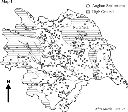
Map 1, illustrates the pattern of Anglian settlement in Yorkshire. It should be noted, however, that in order to avoid overcrowding due to scale, only place-names in -ham, -tun and -ing have been plotted. Notwithstanding this, Morris (1982) claims that the pattern of settlement shown may be considered representative on the grounds that the aforementioned suffixes were both characteristic of, and in common use during, the settlement phase.
 |
Morris goes on to make the following observations:
Chronology
Morris (1982) asserts that, because surviving Dark Age texts are both few in number and obscure in content, establishing an accurate chronology of the progress of this Germanic invasion is somewhat problematic.
At the beginning of the last century, the general consensus among toponymists was that place-names in -ingas (denoting "the followers of") pre-dated those in -ingaham ("the homestead of the followers of"). It was also considered that -ham and -tun sites represented a third stage of place-naming, with the ham type being perceived as the earlier of the two. This view stemmed from the fact that, in contrast to the continuous use of tun for at least a couple of centuries, ham apparently ceased to be employed in place-naming at a comparatively early stage. All these notions persisted until the findings of Cox (1973) and Kuurman (1974).
Kuurman's research focussed on place-names in -ingaham. Employing both geological and topographical methodologies, he found that such settlements were generally of a more attractive nature than those of the -ingas type. In his view, this suggests that the- ingaham sites must have been settled first. Cox shared this opinion. He argued that, because these early invaders were pagan and buried their dead in accordance with pagan rites, as the first settlements, the -ing types should be situated close to pagan burial grounds. However, his findings were that locations in -ing were generally situated some distance from such graveyards. Cox thus concludes that the -ing. types arose from a later stage of colonization when moves were made, via the use of the Roman roads, to exploit fresh land further into the interior
However, the main thrust of Cox's (1973) research was an in-depth study of place-names in -ham. He examined the distribution and location of these sites in relation to the available archaeological evidence. It was found that- ham settlements were frequently located in areas where the soil was good and where the land had natural drainage. Because these were the types of location that would have attracted the early settlers, he concluded that the first settlements must have been of the -ham type.
Comparing his data with that of previous studies, Cox suggests the approximate chronology of settlement as follows:
5th century: -ham
6th century: beginning of the -ingham period
7th century onwards: -ing, -ingas, etc.
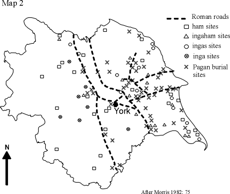
However, with regard to Yorkshire, Cox's claims receive little support from the findings of Fellows Jensen (1972). In relation to the settlement / burial hypothesis, she found little correlation between -ham place-names and pagan burial sites (Map 2). Additionally, Morris (1982) claims that there is even less support for the theory concerning the -ing types as these are rarely found either close to Roman roads or near to the types of burial site mentioned above. Moreover, he says, there appears to be a similar lack of correlation in relation to the place-names in -ingaham.
 |
Nevertheless, Morris does acknowledge that such disparities may be due to lack of archaeological investigation and concludes that chronological order of settlement still remains unresolved. According to some, a similar uncertainty exists concerning the fate of the existing population.
The Celts - displacement or assimilation?
Morris (1982) observes that, at the start of the 20th century, the common belief was that the Britons survived the Anglo-Saxon invasion only by moving west into the Celtic territories of Cumbria and Wales. However, Ekwall (1928) comments on the large number of Celtic names for rivers and streams in numerous parts of England, which were assimilated into Old English, particularly in Wessex, the Midlands and the North. He concludes that this adoption of Celtic names raises some doubt regarding the perceived displacement / extermination of the Britons. Morris (1982) maintains that subsequent toponomastic, archaeological and historical evidence suggests that large numbers of the indigenous Celts survived the Germanic invasion and were integrated into the economic and social life of the newcomers. He elaborates as follows.
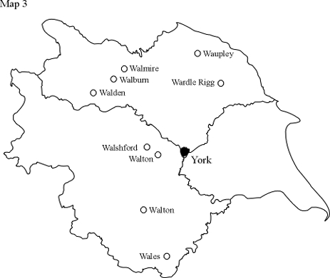
In relation to the toponomastic evidence, he refers to the existence of nine place-names in Yorkshire (Map 3) which contain the Old English element walh (nominative plural walas, genitive plural wala). Meaning "foreigner", "Welshman" or "serf", this is the term that the Anglo-Saxons applied to the Britons. Morris
 |
argues that these place-names, the etymologies of which are given in the table below, support the notion of Celtic enclaves within the boundaries of Yorkshire. He underpins his argument by referring to the archaeological findings. In effect, excavations of the Romano-British villas in Yorkshire have produced no evidence of violence. These structures apparently became derelict through "internal economic forces" long before the advent of the Angles. Finally, in terms of historical evidence, Morris cites, inter alia, the continued existence of the Celtic kingdom of Elmet situated in South Yorkshire.
| Walton (2) | wala + tun (settlement) | Cameron (1988) |
| Walshford | wala + ford (ford) | Thurlow (1979) |
| Walburn | wala + burna (brook or stream) | Cameron (1988) |
| Walmire | wala + mor (moor) | Morris (1982) |
| Walden | wala + denu (valley) | Cameron (1988) |
| Wales | walas | Cameron (1988) |
| Waupley | wala + pol (pool) | Morris (1982) |
| Wardle Rigg | wala + dæl (dale, valley) + hrycg (ridge) | Morris (1982) |
However, as regards the place-name evidence mentioned above, Cameron (1988) issues a word of caution. He observes that there are other Old English place-name elements (e.g. wall - "wall"; wald - "wood") that give the Modern English form Wal- . Furthermore, even if it is conclusively shown that the element is indeed wahl, we cannot be certain whether the meaning is "Welshman" or "serf". Cameron goes on to say that, such place-names would only be given if the presence of Britons was perceived to be a distinctive or unusual feature of the locality; an implication "that the British population of the district was slight".
Resources
Cameron, K. (1988) English Place-Names, Fourth Edition, London: B.T. Batsford Ltd.
Cox, B. (1973) The significance of the distribution of English place-names in -ham in the Midlands and East Anglia, English Place-Name Society Journal V, 15-73.
Ekwall, E. (1928) English River Names, Oxford: Oxford University Press.
Fellows Jensen, G. (1972) Scandinavian Settlement-Names in Yorkshire, Copenhagen.
Fisher, D. J. V. (1973) The Anglo-Saxon Age, London: Longman Group Ltd.
Kuurman, J. (1974) An examination of the -ingas, -inga place-names in the East Midlands, English Place-Name Society Journal VII, 11-44.
Morris, R.W. (1982) Yorkshire through Place Names, North Pomfret, Vermont: David and Charles Inc.
Thurlow, W. (1979) Yorkshire Place-Names, Clapham, North Yorkshire: The Dalesman Publishing Co.Ltd.